

Massive Winter Storm To Target Over 180 Million From Texas To New England With Potentially Damaging Ice, Heavy Snow
- WGON

- Jan 21
- 4 min read
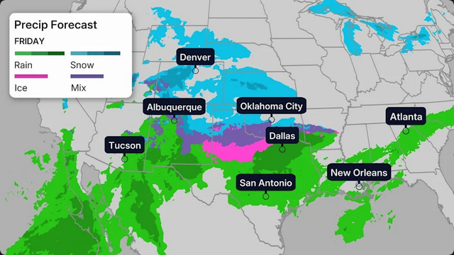
A major, widespread winter storm will hammer parts of the South, Midwest and Northeast Friday through Monday with potentially damaging ice and heavy snow for millions from New Mexico and Texas to parts of New England.
The storm has been named Winter Storm Fern by The Weather Channel. According to The Weather Company forecasters, Fern could affect over 180 million in the U.S. with snow and/or ice, over half the nation's estimated population.
Winter Storm Alerts
Winter storm watches have been issued from New Mexico into the Southeast.
Impacts are expected to be most severe in areas where winter storm warnings and ice storm warnings will eventually be issued. Pay attention to the timing of these alerts in The Weather Channel app.

Timing And Cities Impacted
Friday: Snow, sleet and freezing rain will increase by late morning or early afternoon in the Plains, including parts of Kansas, Oklahoma and northern and western Texas to parts of Arkansas and possibly as far east as the mid-South region of western Tennessee and northern Mississippi.
Cities: Lubbock, Oklahoma City, Tulsa, Little Rock
Friday night: This wintry mess of snow, sleet and ice will continue to sag southward in the Southern Plains and lower Mississippi Valley, and also spread east into parts of the Tennessee Valley and Appalachians as far east as parts of Virginia and the Carolinas.
Cities: Albuquerque, Oklahoma City, Tulsa, Dallas, Austin, Little Rock, Shreveport, Memphis, Nashville, Huntsville, Asheville

Saturday: Snow, sleet and ice could sink even a bit farther south in Texas, Louisiana and Mississippi, while it picks up in Kentucky, Tennessee, West Virginia, Virginia and parts of the Carolinas.
Cities: Albuquerque, Lubbock, Oklahoma City, Dallas, Austin, San Antonio(?), Little Rock, Shreveport, Memphis, Nashville, Knoxville, Asheville, Charlotte, Raleigh, Roanoke, Richmond

Saturday Night: This wintry mess may sag even farther south toward parts of southeast Texas, southwestern Louisiana, central Mississippi, northeast Georgia and South Carolina. Snow may spread into the mid-Atlantic states and intensify while continuing farther west into the mid-Mississippi Valley, Ozarks and parts of Oklahoma and Texas.
Cities: Houston, Dallas, Oklahoma City, Tulsa, Little Rock, Shreveport, Jackson, Memphis, Nashville, Knoxville, Charlotte, Greenville-Spartanburg, Columbia, Richmond, Washington, D.C., Baltimore, Pittsburgh, Philadelphia, New York City

Sunday: Wintry precipitation will end in Texas, Oklahoma and the lower Mississippi Valley by midday, but will persist from the Ohio Valley to the piedmont of Virginia and the Carolinas into the Northeast. Some areas of heavy snow are possible in parts of the Ohio Valley and Northeast.
Some snow and wind may persist in the Northeast Sunday night into Monday morning, before ending.
Cities: Houston, Shreveport, Jackson, Memphis, Nashville, Knoxville, Louisville, Cincinnati, Cleveland, Atlanta (northeast metro), Greenville-Spartanburg, Charlotte, Raleigh, Richmond, Washington, D.C., Baltimore, Pittsburgh, Philadelphia, New York City, Boston

How Much?
Ice
The map below shows where significant ice accumulations are forecast across a broad swath of the South, from parts of Texas to the Carolinas.
In these areas, ice accumulations will be enough not only to make roads hazardous, if not impassable, but also to accumulate on trees and power lines, leading to tree damage and numerous power outages.
If you're in the areas contoured in the map below, you need to prepare for the potential of power outages, possibly lasting hours or a few days, especially considering cold air will plunge into the region during and after the storm.
There is significant uncertainty as to how persistent freezing rain will be in any one area during the storm, and where the line between rain and freezing rain will set up in the Southeast, due to the potential for warmer air pushing farther north.

Snow
It is still too early to give specific numbers as our forecast continues to zero in on this storm.
However, a broad swath from New Mexico, northern Texas and Oklahoma to the East is increasingly likely to pick up heavier snowfall accumulations from Friday through Monday. In general, the heavier snow potential is increasing for the Northeast Interstate 95 corridor from Washington, D.C., to Philadelphia, the New York City Tri-state and southern New England.
This could lead to dangerous travel conditions in these areas. Some roads in parts of the South and Appalachians could become impassable by this weekend.
This is also likely to trigger significant flight delays and cancellations, especially Sunday and possibly early Monday, at the major East Coast hubs.

When Will It Thaw Out?
Compounding the impacts from the storm in the South is a strong push of cold arctic air that may threaten daily cold records across parts of the South, Midwest and East.
Once the storm is over, daytime highs might not climb above freezing until Monday or Tuesday in areas covered with ice or snow in the South. And morning lows may plunge into the single digits, teens and 20s in these affected areas through Tuesday or Wednesday.
This could leave those without power shivering long after the storm. We have important tips on how to cope with a winter power outage here and here.
While increasing sunshine should help thaw some snow or ice during the day, plunging temperatures after sunset may lead to refreezing on roads and several days of slippery travel into early next week.

The Setup
We have a perfect setup expected this weekend, which is why models are leaning toward widespread winter weather.
There are two main factors that will contribute to the setup.

The first is an arctic high that will set up shop over the Great Lakes near the end of the week, which will bring cold air to much of the South.
We also have a storm system that will begin in the Southwest and then head east. Moisture lifting north ahead of the disturbance will cause the rainfall across the South that is expected this week.
With the arctic high pumping in cold air, temperatures will plummet, creating conditions that could be just right for winter weather.


Comments